Detailed map of Kalmykia villages cities. Satellite map of Kalmykia
A map of Kalmykia with regions and transport routes clearly demonstrates that you can get to this region in a variety of ways.
Passengers can use air transport or ground transportation. The satellite map of Kalmykia shows the roads that lead to Kalmykia from Stavropol, Volgograd and other regions.
The Elista-Divnoye railway section communicates with the rest of the railway network. But in most cases, passengers purchase tickets for a train in Stavropol, an air or bus flight.
- when purchasing a ticket for the Moscow-Elista bus route, expect that the travel time will be approximately 24 hours;
- in Moscow you can buy a plane ticket to Elista from Ruslan Airlines, but these flights are very rare;
- You can get to Kalmykia with a transfer by taking a flight to Stavropol, and from there by train or bus.
There is only one airport on the territory of Kalmykia, which is located in Elista. This air complex receives flights from Rostov-on-Don, Moscow, and Mineralnye Vody.
Map of the Republic of Kalmykia with all cities
An online map of Kalmykia with borders shows a vast steppe territory with lakes and several large settlements.
Before heading to the republic, you need to explore the region, find out what attractions there are here. It is best to start getting acquainted with the capital of Kalmykia - Elista. This small but beautiful city, founded in the 19th century, is a kind of oasis in the steppe, where 100 thousand inhabitants settled.
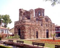
Elista is distinguished by its Buddhist flavor; here are the pearls of Buddhist culture - the Golden Abode of Buddha Shakyamuni Temple. This temple houses many Buddhist relics.
Fans of interesting leisure activities will enjoy the City Chess area. It was built specifically for the 33rd World Chess Olympiad. The Chess Palace is located in the central part, and the complex itself is filled with small cottages, creating the feeling of being in a European town.
Tsagan Aman is located 300 kilometers from Elista. Here is an amazing example of Buddhist architecture, the Tsagan-Aman Khurul Temple.
Kalmykia is a republic within the Russian Federation, located in the southeast of Russia. A satellite map of Kalmykia shows that the region borders the Rostov, Astrakhan and Volgograd regions, Dagestan and the Stavropol Territory. The republic is washed by the Caspian Sea. The area of the region is 74,731 square meters. km.
The republic is divided into 13 municipal districts, 2 cities and 124 rural settlements. The largest cities and villages of Kalmykia are Elista (the capital), the cities of Lagan and Gorodovikovsk, the village of Troitskoye and the urban-type settlement of Yashkul.
The economy of Kalmykia is based on the agro-industrial complex: agriculture and livestock breeding. Industry is poorly developed.
Saiga antelope - an endangered species of antelope
Brief history of Kalmykia
In the 17th century, the Kalmyk Khanate was created on the territory of modern Kalmykia, which became a subject of the Russian Empire. In 1771, the Kalmyk Khanate was quickly liquidated, and the territory became part of the Astrakhan province.
In 1920, the Kalmyk Autonomous Region was created, and in 1935 the Kalmyk Autonomous Soviet Socialist Republic. In 1942-43, the territory was occupied by German troops. In 1943, most of the Kalmyks were deported to Siberia. In 1957, the Kalmyk Autonomous Okrug was recreated, and in 1958, the Kalmyk Autonomous Soviet Socialist Republic. In 1994, the Republic of Kalmykia was formed.

Golden Abode of Buddha Shakyamuni in Elista
Sights of Kalmykia
On a detailed map of Kalmykia from a satellite you can see the following natural attractions: the healing lake Manych-Gudilo, the Yashalta Salt Lake, the Black Lands reserve, where the only population of saigas in Europe lives.
It is also worth visiting the monuments of Buddhist culture - the Golden Abode of Buddha Shakyamuni, the Syakusn-Sume khurul (the Holy Abode of the theory and practice of the Gelug school), the Seven Days Pagoda and the Stupa of Enlightenment in Elista, the White Gate khurul in Tsagan Aman, the khurul in the village of Komsomolsky and the Lagansky khurul.

Golden Gate Altn Bosch in Elista, Kalmykia
In Kalmykia, it is worth seeing the chess town of City Chess, the Chess Palace, the Golden Gate of Altn Bosch and the National Museum of Kalmykia in Elista, and the wild animal center in Yashkul, where saigas are bred.
Note to tourists
Gulrypsh - a holiday destination for celebrities
There is an urban-type settlement Gulrypsh on the Black Sea coast of Abkhazia, the appearance of which is closely connected with the name of the Russian philanthropist Nikolai Nikolaevich Smetsky. In 1989, due to his wife’s illness, they needed a change of climate. The matter was decided by chance.Satellite map of the Republic of Kalmykia
Switching between the satellite map of Kalmykia and the schematic one is done in the lower left corner of the interactive map.
Republic of Kalmykia - Wikipedia:
Date of formation of the Republic of Kalmykia: January 9, 1957
Population of Kalmykia: 278,855 people
Kalmykia telephone code: 847
Area of Kalmykia: 76,100 km²
Vehicle code of Kalmykia: 08
Districts of Kalmykia:
Gorodovikovsky Iki-Burulsky Lagansky Maloderbetovsky Oktyabrsky Ketchenerovsky Priyutnensky Sarpinsky Tselinny Chernozemelsky Justinsky Yashaltinsky Yashkulsky.
Cities of Kalmykia - list of cities in alphabetical order:
City of Gorodovikovsk founded in 1872. The population of the city is 8798 people.
City of Lagan founded in 1871. The population of the city is 13137 people.
Elista city founded in 1865. The population of the city is 103899 people.
Republic of Kalmykia is located in the southeastern part of Russia, occupying territory near Dagestan. The capital of the republic is the city Elista. It is better to start getting acquainted with the republic from the capital, because almost all the attractions of the region are concentrated in this city.
The center of the capital of the republic is full of Buddhist flavor and amazes with its architecture. IN Elista you can see the largest temple in Europe - the Golden Abode of Buddha Shakyamuni. The height of this temple is 65 meters, and inside the building stands the tallest Buddha statue, 12 meters high. The temple also houses several amazing relics, one of which is the clothing of the Dalai Lama from the 14th century.
In Kalmykia there is a unique natural monument - the Big Yashalta Lake, which in terms of healing properties can compete with the Dead.
Sights of Kalmykia: National Museum of Kalmykia, Memorial complex to the soldiers of the 28th Army, Kolonsky Pond, Golden Abode of Buddha Shakyamuni in Elista, Golden Gate in Elista, Manych-Gudilo, Chess City in Elista, Black Lands Reserve, Monument to Ostap Bender in Elista, Salt Lake, Old khurul, Seven Days Pagoda, Golden Gate, Golden Horseman, Holy Cross Church, Lotus Valley.
Kalmykia is located in a zone of sharply continental climate, characterized by hot, dry summers with constant dry winds, and cold winters with little snow. This is the driest region of southern Russia; there are only 3 types of natural zones - steppe, desert and semi-desert. The total annual precipitation does not exceed 340 mm, the average number of sunny days per year is 182, and in winter the air temperature in the northern regions can drop to -35°C.
The length of the republic from south to north is 458 km, from east to west – 423 km, it is located on the outskirts of the southeast of the European part of the Russian Federation. It borders with the Astrakhan, Volgograd and Rostov regions, Dagestan and the Stavropol Territory.
Kalmykia. Map online
(The dotted line indicates the borders of the republic on the map)
The Republic of Kalmykia, being a national-state entity within the Southern Federal District of the Russian Federation, is located on a territory with a total area of 74,731 km². In the east, the republic is washed by the Caspian Sea, the length of the coastline within its borders is 168 km. In the south there is the Chogray reservoir, formed by a dam on the East Manych River, which is used mainly for agricultural purposes. There are few rivers, the largest is the Volga, which crosses the republic in a 12-kilometer stretch. Other rivers: Egorlyk, Eastern and Western Manych, Kuma, Sal, most of them have bitterly salty water and dry up in the summer. The largest lake, the relict Manych-Gudilo, which in prehistoric times connected the Caspian and Black Seas, is located on the territory of the Black Lands nature reserve. The total area of the reserve is 121 thousand hectares, its symbol is the rarest species of saiga antelope.
Districts of Kalmykia:
1. Gorodovikovsky district
2. Iki-Burulsky district
3. Ketchenerovsky district
4. Lagansky district
5. Maloderbetovsky district
6. Oktyabrsky district
7. Priyutnensky district
8. Sarpinsky district
9. Tselinny district
10. Chernozemelsky district
11. Yustinsky district
12. Yashalta district
13. Yashkul district
Cities and towns:
Kalmyks traditionally profess Buddhism. In the capital of the republic, Elista, there is the main khurul - the Buddhist temple “Golden Abode of Buddha Shakyamuni”, which is the largest in Europe. In the city of Lagan you can see a real work of Buddhist art - the Lagan Khurul, as well as entire pink lotus plantations. In total, there are 3 cities in Kalmykia - Elista, Lagan and Gorodovikovsk and 262 settlements. More than half of the population of Kalmykia was destroyed during the years of forced deportation and exile of an entire people to Siberia from 1943 to 1950. The total population according to 2013 data is 284,140 people, the national composition is dominated by Kalmyks, Russians, Dargins, Kazakhs, no more than 44% of the republic’s residents live in cities
 (1 ratings, on average: 5,00 out of 5)