Tourist map of Heraklion in Russian. Heraklion city on the map of Greece
Heraklion on the map of Crete
Detailed map of Heraklion
Heraklion Map
The Greek city of Heraklion or, as it is also called, Heraklion, unnamed after the hero of the famous ancient myth of Hercules, is located on the island of Crete and is its administrative center. Over the several centuries of its existence, the city has changed more than one name - Candia, Heraclea, Khandak, Khandakas, Megalo Kastro.
The map of Heraklion will be useful to everyone who decides to spend their holidays in Crete. Near the city there is Nikos Kazantzakis Airport, thanks to which you can get to the island from the Greek mainland not only by ferry, but also by plane, which is much more convenient and faster.
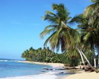
The largest island of Greece is divided into 4 administrative parts - Chania, Rethimon, Lassithi and Heraklion. The latter includes the city of the same name. There are many resorts nearby - Malia, Agea Pelagia, Stalida, Hersonissos. Once in Crete, be sure to study the map of Heraklion with attractions, as this region is famous for its rich architectural and historical heritage. In the Arrivo guide you will find descriptions of the most significant attractions.
annotation: before traveling to the island of Crete, we suggest you familiarize yourself with its administrative center. will give you the opportunity to find your way around the city and see how the main attractions of Heraklion are located. Map of Heraklion in Russian contains the route itself, how to get around these attractions in the shortest way. Version – July 2010.
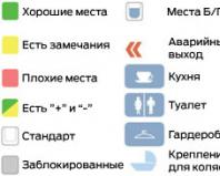
Heraklion Map contains the following designations (marked along the way red dotted line – main tourist route of the city):
1) Venetian fortress (main attraction); 2) Catholic Church; 3) St. Titos; 4) city council building; 5) St. Mark; 6) Lviv Square; 7) Bebo fountain; 8) prefecture; 9) Eleftherias Square; 10) archaeological museum. You will spend one and a half to two hours on this walk. There are many places where you can sit down to relax and have a snack.
Alternative tour. routes are marked on the map with blue and green dotted lines and include:
blue dotted line: 11) Yenikar Aga fountain; 12) St. George's Gate; 13) Bastion of Jesus; 14) Stoa Makasi; 15) grave of Kazanzakis; 16) St. Matthew; 17) St. Minas; 18) St. Catherine;
green dotted line: 18) residence of Chronakis; 19) Frioli fountain; 20) museum of nature; 21) Dermatas gate; 22) historical museum; 23) St. Peter; 24) Fort Kolya.
The map shows symbols for museums, churches, parking spots, taxis, hospitals, pedestrian areas, toilets, hotels, and tourist information points. Read a description of the attractions of Heraklion here.
Download the map of Heraklion in Russian

Map of Heraklion - printed version
If you would like to print a map of Heraklion on A4 paper, please download the image (a fragment of the full map) prepared for printing:
All rights to the map belong to Alfa Plus S.A. (alfaplus.gr). On the ok-tour website. com you can download map of Heraklion in Russian in this edition for informational purposes. Upon arrival in Crete, you can pick up a paper version of the map for free in public places (for example, at the city bus station).
Did you like the article? Click "Like", "+1", "I like it!"
Here is a map of Heraklion with streets → region of Crete, Greece. We study a detailed map of Heraklion with houses and streets. Search in real time, weather today, coordinates
More details about the streets of Heraklion on the map
A detailed map of the city of Heraklion with street names will be able to show all the routes and roads of the Crete region, where the street is located. Davaki, what country, surroundings of the nearest settlement. Located near.
To view the territory of the entire region in detail, it is enough to change the scale of the online diagram +/-. The page contains an interactive map of the city of Heraklion (Greece) with addresses and routes of the area. Move its center to find Krapis Street now.
The ability to plot a route across the country and calculate the distance using the “Ruler” tool, find out the length of the city and the path to the center, addresses of attractions in the region, transport stops and hospitals (type of “Hybrid” scheme), see train stations and borders of the Crete region.
You will find all the necessary detailed information about the location of the city's infrastructure - stations and shops, squares and banks, highways and highways.
What to see:
ancient city of Knossos
An accurate satellite map of Heraklion in Russian with Google search is in its own section, panoramas as well. Use Yandex search to show the desired house on a city map in Greece/the world, in real time.
Here is a detailed map of Heraklion with street names in Russian and house numbers. You can easily get directions by moving the map in all directions with the mouse or clicking on the arrows in the upper left corner. You can change the scale using the scale with the “+” and “-” icons located on the map on the right. The easiest way to adjust the image size is by rotating the mouse wheel.
In what country is the city of Heraklion located?
Heraklion is located in Greece. This is a wonderful, beautiful city, with its own history and traditions. Heraklion coordinates: north latitude and east longitude (show on large map).
Virtual walk
An interactive map of Heraklion with landmarks and other tourist attractions is an indispensable assistant in independent travel. For example, in the “Map” mode, the icon of which is in the upper left corner, you can see a city plan, as well as a detailed map of roads with route numbers. You can also see the city's railway stations and airports marked on the map. Nearby you see the “Satellite” button. By turning on satellite mode, you will examine the terrain, and by enlarging the image, you will be able to study the city in great detail (thanks to satellite maps from Google Maps).
Move the “little man” from the lower right corner of the map to any street in the city, and you can take a virtual walk around Heraklion. Adjust the direction of movement using the arrows that appear in the center of the screen. By turning the mouse wheel, you can zoom in or out of the image.
Heraklion- a city on the island of Crete, which is its capital. If you look at a map of the island of Crete, you will see that the city is located in its northern part. The city stands in a sea harbor on the coast. The city got its name in honor of the hero of ancient Greek legends Hercules. According to legend, in this city he performed one of the 12 great feats.
In contact with
Classmates
In addition to the name of the city, Heraklion is also the name of the region on Crete, the largest of the four existing on the map. The total population of this area is 300,000 people. This area is the most popular among Russian-speaking tourists. Here everyone can find a holiday to suit their taste.
The capital of the island is located in the center of its main transport route. From here you can easily move to both the resorts on the west coast of the island and the east.
History of the city of Heraklion (Wikipedia)
The city of Heraklion was built at the location of a small sea harbor. According to historians, it was a small port on the shores of the Cretan Sea near the city of Knossos.

In 1971, the city was recognized as the territorial and administrative center of the island of Crete.
Modern Heraklion
A modern city named after the hero Hercules (heraklion)– today it ranks fifth in size among cities. This metropolis has a seaport, an airport, many museums and theaters, as well as several prestigious higher education institutions.

The city's attractions
You can explore the capital on your own, starting from the Archaeological Museum - this way you can get the most complete picture of the history of this ancient city, rich in various events.
Among the attractions you should pay special attention to the following:
- Museum of Natural History of Crete.
- Loggia.
- Monastery of Saints Peter and Paul.
- Cathedral.
- Cathedral of Agios Titos.
- Church of St. Catherine.
- Kules Fortress.
- Knossos palace
- Fountains Lion and Bebo.
Knossos palace
The palace is located 5 km from the capital. It is distinguished by the complexity of its architectural form and its structure resembles a labyrinth. The palace is decorated with numerous colorful frescoes that attract the attention of tourists from all over the world. The amazing ceramic finish delights with its beauty and aesthetics. The decoration in the shape of a bee, which was discovered on the territory of the castle, began to symbolize the entire island of Crete.
Lion Fountain (ancient name - Morosini Fountain)
This fountain is almost 400 years old; it was created in 1628. The fountain is located on Venizelo Square, in its very center. In its shape it resembles a giant bowl surrounded by four lions who support it on their backs. There are 8 additional bowls on the ground into which the fountain water flows.
City museums

This museum of modern art was opened in 1983 and is located 15 kilometers from the capital.. This museum is dedicated to the famous Greek writer, author of the famous novel “The Last Temptation” and translator of such world-famous works as Dante’s “The Divine Comedy” and Goethe’s “Faust”. The writer's life presents many mysteries, hiding a lot of secret meetings and diaries hidden from prying eyes that were not known to the general public for a long time. The museum building symbolizes the creative life of the writer, combining a bizarre play of light and shadow. Here you can also see rare video materials and audio recordings.
Another famous museum in Heraklion is the Archaeological Museum, which is considered one of the best Greek museums. It is dedicated to the Minoan culture and consists of 2 floors. There are 13 rooms on the ground floor. On the second floor, in the common room, historical and cultural exhibits are located in chronological order, which are constantly updated and supplied directly from the excavation sites.
The main value of this museum is the Phaistos Disc. This exhibit serves as the only example of Minoan writing and is therefore impossible to decipher and translate into modern language.
Cretan Cathedral of Titus
The Cathedral of Titus is located in Heraklion and belongs to the Orthodox churches of Greece. The cathedral was named in honor of the patron saint of the island, who preached Orthodoxy on the island in the 1st century and was canonized. It was built on the orders of Nikephoros II Phocas, the future emperor of Byzantium. The relics of St. Titus are kept at the entrance to the cathedral. Over many centuries, during the conquest of the Venetians and Turks, the temple was turned into a Catholic church, then into a mosque. Over time, the temple returned to its original Orthodox roots, was consecrated according to Orthodox canons, and the minaret was converted into a bell tower.
Kules Fortress

This fortress is one of the most beautiful places in Crete and Heraklion. The structure has been preserved since the time of Venetian rule. This fortress was built to protect against attacks by invaders from the sea. In the 16th century, the fortress was restored after a devastating earthquake, which left only ruins at the fortification site. The restored fortress has retained its appearance to this day. For some time there was a mosque in the fortress. It was subsequently rebuilt into a lighthouse, which remains there to this day.
Since all city attractions are located close to each other, you can get around them on foot using a virtual map. All of these cultural and historical monuments of Greece are located in the Old Town and are easily visible from the 25 August embankment.
The new district of the capital has on its territory modern universities, theaters, business and cultural buildings, an airport and a seaport, which are strategically and economically important transport hubs.
 (1 ratings, on average: 5,00 out of 5)