Mysterious and harsh Shantar Islands. Tours to the Shantar Islands from the Moscow travel agency St. Astur, expedition to the Shantar Islands, Shantar Islands, travel to the Shantar Islands cost, trip to the Shantar Islands, the archipelago beyond the edge of the earth Bolshoy
The Shantar Islands are a bear paradise, where clubfoot live freely, because it is forbidden to hunt them here. But it is also a paradise for a geologist: along the shores of the islands, rocks are located in a picturesque mess, painted in the most unexpected colors: pink, red, green, white ...
This is not a joke of nature, but layers of jasper, marble and other rocks that come to the surface.
The word "shantar" in translation from the language of the Nivkh people means "island", and it is precisely this word that is incorporated in the name invented by the discoverers of the archipelago.
The Shantar archipelago consists of a dozen and a half islands of various sizes, clustered close to the mainland in the Sea of Okhotsk. The islands are located right at the entrance to the Udskaya Bay, Tugur Bay and Academy Bay and are separated from the mainland by the Lindholm Strait and the Shantar Sea.
The relief of the islands is very uneven, mountainous. Valleys of small rivers lie between the mountains, and swamps stretch along the banks of the rivers in the lowlands: there is simply nowhere for water to seep, under a small layer of soil there are hard rocks and granite.
.png)
The shores of the islands are high and rocky, plunging steeply into the sea. The sea around the islands is full of huge pitfalls that pose a great danger to ships. Nature, as if on purpose, took care to make the islands as inaccessible as possible: there are no convenient harbors here, with the exception of Yakshin Bay on Bolshoi Shantar and Swan Bay on Fekpistov Island.
Navigation in the area of the Shantar archipelago is dangerous, it is not recommended to swim here for ships that do not have radars. The speed of the currents in these parts can reach eight knots, that is, about 15 km / h.
From October to June, the Uda Bay is frozen, the water around the Shantarek Islands freezes, and they practically merge with the mainland for most of the year.
The islands of Maly Shantar and Belichiy are separated by a narrow strait, navigation here is risky, for which the strait is called Dangerous.
The indigenous people of the Nivkhs were the first to develop the islands. Since there are relatively few islands in this place off the coast of the Sea of \u200b\u200bOkhotsk, the Nivkhs called them "shantar", which in translation from their language simply means "island".
In 1639, the Cossacks of Ivan Moskvitin, Vasily Poyarkov and Ivan Nagiba reached the islands.
They used a word from the Nivkh language, calling them Shantar, that is, "island islands." However, for the first time the name Shantar appeared on a geographical map compiled in 1710. Since the islands have not only commercial, but also border value, Emperor Peter II in 1728 ordered: “Russian and foreign hunters should be released to the Shantar Islands for fishing, so that they authentically notified what peoples live on those islands.
The names of geographical objects on the islands were given by local hunters and fishermen and reflect the appearance of the object: on Feklistov Island - capes Rogaty, Pokaty, Bely, Primetnaya Skala, Krasny, on the island of Maly Shantar - Cape Gorbaty. And Sugarloaf Island got its name from its obvious resemblance to the said product. The rich fauna of the archipelago is captured in the names of the islands Squirrel, Bear, Bird, Utich and Steller's Stones.
The islands have never had a permanent population: it is difficult even for a hermit to survive here. For a long time, hunters and fishermen came to the islands from the mainland - and returned back with a catch and a hunted animal. True, in 1830-1831. the Americans created a company that settled on Bolshoi Shantar, but soon the settlement was abandoned and people returned to the mainland: the income from the crafts turned out to be negligible compared to the costs of maintaining the winter hut.
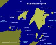
The Shantar Islands are an archipelago of 15 islands in the western part of the Sea of Okhotsk. The largest islands are Big Shantar, Feklistova, Little Shantar and Belichiy. The Shantar Islands are officially part of the regions of the Far North (a part of Russian territory located mainly north of the Arctic Circle), but are located at the same latitude as Moscow.
There are a lot of birds on the Shantar Islands, there is an incessant noise from bird colonies. In 2013, a reserve was created here to protect the island fauna.
The nature of the Shantar Islands is not much different from that on the mainland, across the strait: the same dark coniferous forests of fir and Siberian spruce, the same Gmelin larches on the slopes of the mountains, and on the peaks - thickets of elfin cedar.
.jpg)
The area of the Shantar Islands is not an easy place to survive: there are constant typhoons and fogs, most of the year there are burning frosts.
Fog constantly hangs in the area of the Shantar Islands, which do not dissipate even with a strong wind due to cold water. The reason is that here is the most frozen region of the Sea of Okhotsk: a cold northeast wind blows and ice clogs the straits between the islands.
The tidal currents around the Shantar Islands are among the fastest in the oceans. They rush with force into the inter-island straits, resembling turbulent rivers, and then the roar of the rushing water is heard for several kilometers.
The local harsh nature is diversified by many rivers and streams, forming about a hundred waterfalls from 10 to 100 m high.
Despite the difficult climatic conditions, these lands are rich in flora and fauna. Dozens of rare species of plants and animals are found here. There are more than two hundred species of birds alone in the archipelago, of which eleven are marine species, and most of all are colonial nesting (bazaars) of spectacled guillemot, hatchet, ipatka, cormorants and various types of gulls.
On the islands there are large rookeries of pinnipeds: sea lions, bearded seals, spotted seals, akiba. In coastal waters there are a lot of mykizha, kunzha, chum salmon, smelt, char, pink salmon, rudd, Dolly Varden and lenok.
In addition, many species of mammals live on the Shantar Islands, especially predators: brown bear, wolf, common fox, raccoon dog, wolverine, otter, ermine, weasel, sable. There is no shortage of food here: there is enough birds and fish to feed all year round.
Now there is no permanent population on the islands, except for a few employees of a weather station on the northeastern shore of the Yakshina Bay of Bolshoy Shantar Island.
On the islands, in some places, you can still find evidence of a flourishing whaling industry - rusty equipment and the remains of primitive salotop factories.
Closest to the islands is the village of Chumikan - a port in the Uda Bay of the Sea of \u200b\u200bOkhotsk, at the mouth of the Uda River, and the administrative center of the Tuguro-Chumikansky district.
Taking into account the special value of the Shantar Islands region, the entire archipelago, together with the water area, was included in the Shantar Islands state nature reserve of federal significance in 1999 with an area of 515.5 thousand hectares. .jpg)
Location: Sea of Okhotsk, Pacific Ocean.
Islands: Big Shantar, Feklistova, Maly Shantar, Squirrel, Bear, Bird, Utichy, Sugarloaf, Kusova, Prokofiev, Sivuchy Stones, Sukhotina, Northern, Middle, Southern and Diomede Stones.
Origin: Continental.
Administrative affiliation: Tuguro-Chumikansky district, Khabarovsk Territory, Russian Federation.
Where is it, how to get there:
The nearest settlements (all on the mainland, belong to the Tuguro-Chumikansky district): Chumikan village - 1147 people. (2011), Tugur settlement - 387 people. (2011).
Languages: Russian, Evenki.
Ethnic composition: Evenks, Russians.
Religions: Orthodoxy, shamanism.
Large rivers: Deer, Middle, Big Anaur, Yakshina (all - Big Shantar).
Large lakes: Karpino, Bolshoi and Maly Omokoi (Big Shantar), Lisye (Feklistova).
Monetary unit: Russian ruble.
Nearest international airport: Novy airport in Khabarovsk.
Area: about 2500 km2 (Big Shantar - 1766 km2, Feklistova - 372 km2, Small Shantar - about 100 km2, Squirrel - about 70 km2, others - Bear, Bird, Utichy, Sugar Loaf, Kusova, Prokofiev, Sivuchy Stones, Sukhotina, Northern, Middle, Southern and Diomede Stones - 192 km2).
Tides: irregular, semi-diurnal, up to 10 m high.
Average altitude above sea level: about 100-200 m.
The highest point: Mount Veselaya (Big Shantar, 720 m).
Economy
Sea fishing.
Service sector: tourism, transport, trade.
.jpg)
Attractions
■ Natural: Bely Cape (Feklistov Island, marble rocks), Red Cape (Feklistova, jasper rocks), Olenya River, sheer coastal cliffs (Prokofiev Island), Lion Stone rock (Bolshoy Shantar), rock “with a hole” (Small Shantar), kekurs (Utichy), bird colonies, rookeries of marine mammals. National Park "Shantar Islands".
■ Others: weather station (Bolshoy Shantar), abandoned American lard factory (Bolshoy Shantar), old cemetery (Bolshoi Shantar).
Curious facts
■ Suloi is a surge of water on the sea surface, which occurs, in particular, with a sharp decrease in the speed of the tidal current, as well as with the collision of multidirectional flows or with strong winds directed against the current. The water surface in the zone of rips is similar to gurgling and boiling water. Most often, rips are observed in the straits and in the mouths of rivers. In the area of the Shantar Islands, the suloi reaches a height of 3-4 m and poses a danger to small vessels.
■ Thirty species of birds inhabiting the Shantar Islands are listed in the Red Data Book of the Russian Federation.
■ The Lindholm Strait was named after the Finn Otto Lindholm, a major entrepreneur who was at the origins of whaling in the Far East in the middle of the 19th century.
■ The name "Shantar Sea" was first used by whalers in the 19th century. Today this name is preserved on old topographic maps. It was mentioned on nautical charts and in sailing directions until the middle of the 20th century, and then disappeared, as well as from new topographic maps. The reasons for cartographers' rejection of this name are not at all ideological: insignificant - according to cartographers - the size of the "sea" and the fact that it was originally called a lip (bay).
■ Kusova Island was discovered in 1829 by the Russian hydrographer P.T. Kozmin and named after the director of the Russian-American company N.I. Kusova.
■ The Shantar Islands is an area of the strongest geomagnetic anomaly, which causes the compass needle to continuously spin clockwise.
■ The Srednyaya River on Bolshoi Shantar is the only place on the entire coast of the Sea of Okhotsk where mykizha, or rainbow trout, lives, a species listed in the Red Book of the Russian Federation.
■ In the Sea of Okhotsk, on the shelf exclusively in the area of the Shantar Islands, an endemic will grow - the brown seaweed kelp angustata. This marine organism is used in the food industry and medicine.
.jpg)
GENERAL INFORMATION
The Shantar Islands is an archipelago belonging to Russia in the Sea of Okhotsk at the entrance to the Uda Bay, the Tugur Bay and the Bay of Academy, separated from the mainland by the Shantar Sea and the Lindholm Strait, administratively part of the Tuguro-Chumikansky District of the Khabarovsk Territory. The name probably comes from the Nivkh "ch'and" - "to be white."
The discovery of the Shantar Islands is attributed to Vasily Poyarkov and attributed to 1645. The first inventory and topographic survey of the islands on behalf of the Russian-American Company was carried out by Prokofy Kozmin in 1830-1831. The first scientific research was conducted by the Russian scientist-traveler Alexander Middendorf, who visited the islands in August 1844. In July 1910, the Amur Governor-General P.F. Unterberger visited the islands. It was he who determined that the Shantar Sea (Shantar Bay, Ulban and Tugur Bays) is inland and foreign whalers are not allowed to enter there.
It includes 15 islands: Bolshoy Shantar (the island crosses the Stalin Range), Feklistova, Maly Shantar, Squirrel, Bear, Bird, Utichy, Sugar Loaf, Kusova, Prokofiev, Sivuchy Stones, Sukhotina, Northern, Middle, Southern and Diomede Stones. The total area of the archipelago is about 2.5 thousand km².
The landscape of the islands is mountainous, the maximum height is 720 m, according to other sources, 701 m (Veselaya Mountain on Bolshoi Shantar).
The Shantar Islands belong to the regions of the Far North.
In 1830-1831. on the island of Bolshoy Shantar, the Russian-American company founded a settlement, but it was abandoned, since the fisheries were insignificant.
In 1926, a settlement (island economy) appeared on the island of Bolshoi Shantar, which was successively in the systems of Dalgostorg (since 1926), the Joint-Stock Kamchatka Society (AKO) since 1928, the Soyuzpushnina Dalzverokombinat (since 1932) and the Ayano-Okhotsk fishery. trust of the People's Commissariat of Food Industry. Since 1934 - as part of the Chumikan Village Council, in 1956 - with. Shantar of the Shantar Village Council (settlement Big Shantar, Northern Cape). April 25, 1968 - the village council was abolished.
Vegetation
Large islands are covered with larch and dark coniferous forests, in which Ayan spruce, Daurian larch, dwarf pine, and birch grow. There are thickets of cedar elfin.
The first collection of plants (130 species) was collected by Alexander Middendorf in 1844, processed by the systematist-botanist Karl Meyer and the botanist-naturalist Rudolf Trautfetter. The second collection was held in 1924-1926. scientific and fishing expedition of Dalryba and Dalgostorg (compiled by: A. D. Baturin - head of the expedition, zoologist G. D. Dulkeit - assistant of the head of the expedition, I. M. Goncharov). In 1927, a hydrobiological expedition of the Pacific Research and Trade Station (TIRKh) worked: G. I. Zaks, A. G. Kuznetsov and A. P. Vvedensky, collecting herbarium material, including a herbarium of algae.
In 1907-1908, in 1911-1912. A forest inventory expedition of the Ministry of Land Management and Agriculture of the Russian Empire, headed by O. V. Markgraf, vice-inspector of the Corps of Foresters, worked (zoological and soil collections).
In 1928, the Pacific Research and Trade Station summarized materials on the vegetation cover of the islands, author. I. K. Shishkin. He divided the vegetation cover into groups: 1. spruce forests; 2. larch forests; 3. moss swamps; 4. thickets of herbaceous vegetation; 5. urema along the banks of rivers; 6. vegetation of rocks and outcrops; 7. vegetation of the sea coast; 8. thickets of cedar elfin. List of 227 plant species.
In 1947-1959. - Khabarovsk botanist A.P. Nechaev worked.
In 1970, the expedition of the Forest Department of the Biological and Soil Institute of the Far Eastern Scientific Center of the USSR Academy of Sciences.
In 1986, the Amur branch of the Russian Geographical Society organized a comprehensive expedition to study the ecosystem of the archipelago.
In 1999, the botanist L.A. Antonova visited the islands.
.jpg)
Animal world
In the 19th century, researchers rarely visited the Shantar Islands because of their inaccessibility and remoteness from the main sea routes. The first description of the birds found on the islands was compiled by the Russian traveler A.F. Middendorf in 1851 based on a trip in 1844. At the beginning of the 20th century, in the course of two years of work on the islands (in 1924-1926), the zoologist G.D. Dulkeit described 214 species of animals. The results of his work formed the basis of the first list of birds, which he compiled together with the Soviet ornithologist L. M. Shulpin. The list included 172 species of birds. The Soviet ornithologist V.D. Yakhontov in the second half of the 20th century added to the list up to 205 species. Having worked on the archipelago on expeditions in 1971, 1978, 1982, 1986, 1991 and 1992, G.E. Roslyakov completed the work begun by his fellow ornithologists.
In 1928, a hydrological and hydrobiological expedition of the State Hydrological Institute worked, and in 1930-1931. — Expedition of the Joint-Stock Kamchatka Society (AKO) and the Amurrybaksoyuz to study the prospects of marine fur hunting.
Since 1935, the main direction of the island economy has been defined as fur farming, the main object of which is sable bred in the wild (by 1936, the sable herd reached 1500-1600 animals).
Many predatory mammals live on large islands: brown bear, wolf, common fox, raccoon dog, wolverine, otter, ermine, weasel, sable.
There are 11 species of seabirds on the archipelago. The most numerous species is the spectacled guillemot. The number of individuals and the number of bird colonies varies considerably from year to year. Scientists noted that in 1971, 1978 and 1982 the number of these birds nesting in the archipelago reached 18000÷20000 pairs. The largest colonies numbering 7,000 and 3,000 pairs were located on the islands of Utich'e and Ptich'e. At the same time, in 1991-1992, 17,500 pairs nested on Utichye alone.
In 1999, the Shantar Islands with the water area were included in the state nature reserve of the same name of federal significance. In 2013, by a decree of the Russian Government, the Shantar Islands National Park was established with a total area of 515,500 hectares, including the adjacent water area of the Sea of Okhotsk with an area of 274,284.08 hectares. The territory of the national park consists of 4 sections, including groups of islands of the Shantar archipelago. All sections of the national park are located in the Tuguro-Chumikansky district of the Khabarovsk Territory.
The waters around these offshore islands are frozen for about eight months on average per year, so they merge with the mainland for most of the year.
Climate
The climate is temperate monsoonal, in terms of temperature regime with features of the subarctic. In winter, in the rear of the Okhotsk cyclones, icy air is carried out from Siberia. In summer, the cooling effect of the sea affects.
.jpg)
BIG SHANTAR ISLAND
Bolshoy Shantar is the largest island of the Shantar archipelago. Since 1999, together with other islands of the archipelago, it has been included in the Shantar Islands State Nature Reserve. Since 2013, it has been included in the Shantar Islands National Park, established by the Decree of the Government of the Russian Federation.
A hydrometeorological station is located on the northeastern shore of Yakshina Bay.
Area - 1766 sq. km. The length of the island from north to south is 65 km, from west to east along the 55th parallel - about 47 km. The northern tip of the island is Cape Severny, the southern one is Cape Philip, the western one is Cape Rainbow, and the eastern one is Cape North-East.
In the northeastern part of the island there is Lake Bolshoi, connected to the sea by a narrow strait. The Olenya River flows into the lake with a tributary of the Middle. The Yakshina Bay deeply protrudes into the southwestern coast of the island, into which two large rivers flow: Bolshoy Anaur and Yakshina. The bay partly dries up during low tide.
The highest point of the island is Mount Veselaya with a height of 720 m, according to other sources 701 m. Other peaks: Mt. Anaur (637 m), Mt. Dry (586 m), Mt. .
Most of the island is covered with coniferous forest, which is based on spruce and larch. In the southern part there are birch and alder. There are two species of small-mouth smelt in Lake Bolshoy: the small-mouth sea smelt (Hypomesus japonicus) and the small-mouth river smelt (H. olidus).
The island is mentioned in the computer game Grand Theft Auto IV as the location of the headquarters of the fictional Shitster program.
In Soviet times, a military unit was located on the island.
In 2016, about 2 thousand metal barrels and several pieces of equipment were found to be disposed of. In 2017, the island is being cleaned of large-sized metal debris. The work is being carried out by the environmental unit of the Eastern Military District of the Russian Armed Forces.
Diomede stones
At a distance of about 2.5 km south of Cape Philip is an island (rock) Diomede Stones
Feklistov Island is the second largest island of the Shantar archipelago. It is located to the west of Bolshoi Shantar and is separated from it by the Northern Strait. The area of the island is 372 sq. km. The length of the island is about 40 km, the highest point is 485 m (Povorotnaya). Most of the island is covered with taiga. In the northern part of the island there is Lake Lisye, into which the river of the same name flows. The Lebyazhya Bay juts out into the southern coast of the island with the bays of Rosset, Sobolev and the roadstead of Enegelm.
A placer occurrence of platinoids was found on the island.
Sukhotina Island
Sukhotina Island is located at the entrance to Lebyazhya Bay at a distance of about 800 m from Feklistov Island and is separated from it by the Uzkiy Strait. Sukhotin Island was described in 1885 during the hydrological expedition of the Abrek clipper and, according to some sources, was named after I. V. Sukhotin.
The Feklistov and Sukhotin Islands are part of the Shantar Islands State Nature Reserve of federal significance.
NATIONAL PARK
The Shantar Islands National Park is a national park of Russia, established on December 30, 2013 in order to preserve the unique natural complexes on the Shantar Islands in the Sea of Okhotsk. It is under the jurisdiction of the Ministry of Natural Resources and Ecology of Russia, a branch of the Federal State Budgetary Institution "Amur Reserve".
The director of the national park is Nasonov Ivan Anatolyevich.
The national park is located in the eastern part of the Sea of Okhotsk, administratively part of the Khabarovsk Territory. The total area of the park is 5155 km², including 2412 km² of forest land in the Tuguro-Chumikansky district, 2743 km² of water fund land in the Sea of Okhotsk.
This status of the island and the adjacent water area could not receive more than 40 years.
According to Boris Voronov, Corresponding Member of the Russian Academy of Sciences, the first attempts to organize a reserve on this territory date back to 1975. In 1999, Decree No. 249 was adopted on the organization of the Shantar Islands natural state reserve. Then, for 15 years, work was carried out on the creation of a national park, in which scientists, public organizations and environmentalists took an active part. However, the damage from the activities of poachers in the region is still being felt. According to ornithologist Vladimir Pronkevich, even modern tourists do not disdain poaching.
The Shantar Islands have been included in government plans for the development of a system of specially protected natural areas of federal significance since 2001.
In 2011 Gennady Basyuk, chairman of the public committee "Saving the Shantar Islands" (Khabarovsk) under the All-Russian Organization for Public Opinion and Culture, wrote three letters to V.V. Putin, expressing concern for the fate of Shantar. In them, he spoke of the need to resolve the issue of protecting the water frontiers of Russia, the security forces of the Shantar Islands and the entire Sea of Okhotsk. In January 2013, he urgently convened a press conference, stating that an encumbrance had been imposed on part of the territory, more precisely, the land of the largest island of the archipelago - Big Shantar - was leased from a private structure and its term was ending, the territory was put up for renewal of the lease. After the press conference, the lease was not extended; in the same year, the national park appeared.
As of the summer of 2014, the national park exists "only on paper", but huntsmen and scientists should soon appear on the islands, it is planned to repair and put into operation the runway, and ecological trails should appear over time. The number of employees of the national park will be about 30 people.
In October 2016, a group of scientists went to the islands for the first time since the establishment of the national park.
In the same year, a working expedition of specialists from the environmental service of the logistics headquarters of the Eastern Military District and the regional environmental center was sent to the islands, and an assessment was made of the amount of work to clean up the territory. In 2017, it is planned to clean up the island of Big Shantar from large-sized metal debris. As of January 18, 2017, the staff of the environmental platoon of the Eastern Military District was formed, and a map of the territory clearing was prepared. In the autumn of 2017, 12 containers with equipment for processing metal waste on site (cutting and pressing metal) will be delivered to the island. In total, about 2 thousand metal barrels and several pieces of equipment to be disposed of were found on the island.
Starting from the summer of 2017, cruise routes are planned to enter the territory of the national park. The use of water transport (against air) should significantly reduce the cost of the transport component of the excursion tour.
Meaning
The unique island ecosystems of the Sea of Okhotsk are a combination of natural complexes of the northern taiga and mountain tundra with elements of original flora. On the islands, there are rare species of animals and plants listed in the Red Books of the Russian Federation and the Khabarovsk Territory, there are rookeries of pinnipeds, in the river of the Srednyaya Island of Bolshoi Shantar, mykizha fish lives - a unique Shantar population of this species, included in the Red Book of Russia.
Large islands are covered with larch and dark coniferous forests, in which Siberian spruce, Gmelin larch, dwarf pine, and birch grow. There are thickets of cedar elfin.
Many predatory mammals live on large islands: brown bear, wolf, common fox, raccoon dog, wolverine, otter, ermine, weasel, sable.
There are 11 species of seabirds on the archipelago. The most numerous species is the spectacled guillemot. The number of individuals and the number of bird colonies varies considerably from year to year. Scientists noted that in 1971, 1978 and 1982 the number of these birds nesting in the archipelago reached 18,000–20,000 pairs. The largest colonies numbering 7,000 and 3,000 pairs were located on the islands of Utich'e and Ptich'e. At the same time, in 1991-1992, 17,500 pairs nested on Utichye alone.
In the water area, you can see bowhead whales approaching quite close to the shores of the islands.
JOURNEY TO THE SHANTAR ISLANDS
In our case, it was necessary to first fly by plane for 8 hours, then travel by bus for 14 hours along the roads of the Khabarovsk Territory (in some places along a very broken and washed out road), and then, in the case of helicopter-flying weather (and we were waiting for such weather 9 hours), fly by helicopter for 1.5 hours ... and here we are on the Shantar Islands, islands that are scattered in the Sea of Okhotsk. We will visit several islands, but so far the helicopter has thrown us to the largest island, which is called Big Shantar.
I know there are edges...
I know there are edges - go, look, try
There is such a land, there is such grass,
And there are no forests like in those places anywhere, brother, in sight.
There is water in the lakes, like God's dew,
There, stars sparkle with diamonds and fall into the mountains.
I would go there, only where can I get a ticket ..
The Shantar Islands are the dream of those who are attracted by wild nature, harsh conditions (there is a short summer, there are ice in July, and in September the sea is again covered with ice). There is often fog here, in some places there are "crowds" of mosquitoes and midges and sooo big ebbs and flows. There are fantastically beautiful bays, rocks. Seals, killer whales, whales swim among icebergs in the sea. Bears, foxes, deer roam along the banks, there is a hubbub from bird colonies, and the rivers are full of fish. Here are amazing animals that are not afraid of people, and sometimes even smile when they meet.
True, at night you don’t want them not to be afraid of you, and you don’t want them to walk around the tent. Therefore, sometimes I had to be on duty at the post, and "shoot back." I don’t have a very good view here, after all, I’m on my feet all night, don’t spam.
Once I fell asleep at the "post" and this is what I found next to my slippers in the morning ... Well, Misha did not take away his shoes, the size did not fit.
The trip itself around the islands takes place on boats in which you can comfortably spread out, and if you are tired of looking out for killer whales and seals, you can take a sweet nap. For example, like this:
And of course, you need to experience the extreme! What is this adventure if there was no extreme? So, for example, we "ran away" from killer whales. We looked for them in the distance, and in some amazing way they moved right under our boat ...
From Khabarovsk to Briakan (from where we have a helicopter transfer to Bolshoy Shantar) 14 hours by bus. On broken Far Eastern roads: somewhere on asphalt, somewhere on a dirt road, in some places the road is washed out. At 6 am we arrived at the heliport in Briakane. And the first helicopter, in flying weather, takes off at 9-10 am. There is a small hotel "Hilton" here (by the way, we went here by bus "5 stars"). It is still very early and the Hilton is busy - crests are sleeping here now (they came purely for fishing, they go to Shantar every year).
They were supposed to take off yesterday, but the weather is not flying, it's raining, and they hovered here. While away the time in the gazebo. Soon the crests got up and time went unnoticed - under the bacon, vodka, and under the conversations ...
In the morning the helicopter did not fly away, it was foggy, but in the afternoon they sent crests to the island and finally we flew out at 6 pm. 1.5 hours of flight - and we are on the Big Shantar! We promptly disembarked, and the group immediately loaded up for departure from Shantar. The vertak sits right on the shore. In the evening on the shore - "CU" how to behave in the wild and when meeting a bear (which is very likely here)!
The bear came at night. Rather, in the morning. Khokhols (our acquaintances) camp nearby, across the river (and when the tide is low, it is not a river, but a small stream, and you can walk to the Khokhols across the "river"). So early in the morning (it was still dark) they shout “Muscovites, the bear is coming!”, And the second voice adds “with our fat”! Bears may not be very scary for people now (a lot of fish and berries), but they can tear up boats, and boats are our EVERYTHING. So crests continue to shout “bear 70 meters from the boat”, and immediately after another voice “no, 30 meters”! Guide Vova jumped out in what he slept (only put on a vest with cartridges) with a gun and a rocket launcher to scare away the bear. He drove for about 30 minutes - and shot and said in a rude voice "get out of here, go away"! It's creepy - that he is so close and had to scare him for so long. In the morning it turned out that he snatched all the same and we had half a loaf of sausage and grabbed butter with his paw.
In the morning the weather is excellent, seals are swimming - but somehow far away. No wind, no sunshine. Today we explore the shore where the camp stands - we walked along the shore - beautiful rocks, a cliff. The fog stretches in and out. The first time we went out to sea - we swam to fresh water - on a boat for about 30 minutes on the water to the waterfall.
In the morning we remove the camp and leave along the island. A little more than an hour - and we are at the weather station. It is here that the only people on all the Shantar Islands live - only 4 people of the population. And these four people - keep records of weather, precipitation, transmit data, etc.
There was once a mini-factory for the processing of whale oil, the fat was processed into oil. Now everything has been torn apart piece by piece, the frames that remain are naturally rusted. While we were walking around the weather station (and we only walked for a couple of hours), the water left a lot and the boats were aground. What to do, then, we rest for three hours, waiting for the tide - we eat, walk, sleep, read newspapers, guess crossword puzzles.
Well, our fishermen (three Khabarovsk residents) went fishing (they returned with prey - with pink salmon). Anatoly Dmitrievich came - a local aborigine, a celebrity. He has been living on the island for a long time, once he hunted sables, but he still remained to live on the island. Lived alone, now lives at the weather station.
About five came the water. We load and go to Topaznaya Bay. There is also fresh water here - the Topaznaya River.
The place is wonderful. There is enough space on the shore for tents, there is where to walk along the shore, and the river nearby pleases.
We sail to the Utichy Islands. It’s sunny on the shore, but in the sea it’s cooler in any case, and closer to Utichema there’s also fog. The islands are in thick fog and almost nothing is visible. They say that once a small plane crashed here (these islands have not yet been mapped).
Through the fog they returned to our bay. But in our bay it is sunny and joyful!
The guys built a shower room, so today we will wash! We also swam in the sea, it burns, but tolerable. We walked through the forest. We found the remains of a house (lower masonry) and a rusty fire extinguisher. Go crazy, and it's who in the forest cut down and equipped the hut. And this is decently deep into the island (about 20 minutes) and the mosquito is here !!!
In the evening, our fishermen went to sea, and pleased us with sea gobies.
The bear came at night. In the morning they understood, because the barrel with food was overturned and the sausage, cheese were scattered on the sand (in the following days, all the most valuable food was hung on a tree), and even then they saw footprints on the beach.
We are in the same bay. We were supposed to go to Feklistov, but we passed the wind, so we are waiting for the weather. We went up to the cape. The fog cleared, the view of the bay and the camp opened up. The rise is about an hour, somewhere there is a path, somewhere along the spruce branches we go.
The guys made a camping bath - a real one. They heated the stones, laid the floor with juniper twigs, covered it with an awning - a real steam room (pictured behind me). And the smell!!! And from the steam room - dive into the burning Sea of Okhotsk! Beauties!
At night they decided to guard the bear. We set an alarm clock for 4.30 (it dawns at five, this is to see him at dawn). They got up in the morning, waited, but he did not come ...
And in the morning we still saw his footprints on the beach! In the darkness, it turns out, he came. Anyway. Let's catch him anyway...
The day before they gave the weather to go out - the wind is decreasing. We leave on the Feklistov Island (the second largest after Bolshoy Shantar), on the Swan Bay. Walk about 50 km, it's 4-5 hours by sea. The fog is small. We load, sit down .. and it starts to rain! Not a downpour, but it floods from above - from the sky, and floods from the sides, from the sea. But he soon passed. We ate on board.
We walked to Feklistov exactly 4 hours. Big bay. And how many mosquitoes! Above the shore there is a hut (winter hut). Of course, abandoned, and of course, walked by a bear. The beach is strewn with flowers.
There is a river - and our fishermen immediately went fishing. Drying off. Someone went for a walk along the coast, someone is sitting on the beach, someone is helping in the kitchen.
Some people got wet and cold - not everyone received detailed information on equipment, and in general on the specifics of the trip. Because of which they sometimes froze. But a bottle of 5 liters (do not think that water!) And a can of stew saved from all sorts of colds!
Let's go to Bird Island. We get up at 8 in the morning, have breakfast, and sail at 11. Swim for about 5 hours. A little foggy, sometimes it starts to drizzle. P.S. our fishermen are fishing again in the morning and, of course, again with fish! We went out on the natural Arch and examined small caves nearby.
Running weather - no waves, the sun is in the fog. Snack on board. And here it is, Bird Island! The shore is littered with driftwood, and beautiful boulders stand along the shore. And the most decoration of the bay is a snowfield!
The island is small - 2.5 km long and 1.5 km wide. Until the fog settled, we went up the snowfield (again, you can’t go far, bears!), There are traces (or rather waste) of a bear. True, they say, most likely last year (the question is - did he swim away from the island ??). But still, since the island is small, and the only source of fresh water is a snowfield, if there is a bear on the island, he will definitely come here .. so you need to be careful. Fog creeps in and gradually covers the island and us..
What is good, there are no mosquitoes at all (which tormented us on Feklistov Island).
At night, someone small wandered not far from the tent, pebbles rustled ... But it seemed to me that it was a huge bear walking right next to my tent. In general, I suffered from fear ..
Morning. Birds-birds-birds (Ptichy Island). Large colonies of spectacled guillemots are located on the island. Nebula around the island. We're going to the mainland. The weather is pleasant, a little cool breeze. We sail to Ongachan.
We sailed around 12 noon, after a couple of hours ice appeared - separately floating pieces, some took bizarre shapes.
On the way we meet surprised seals (probably never seen people).
And then we "rested" in the ice field. Walked around it with the utmost care.
And suddenly ahead - killer whales! The fins rise above the water. While they were looking out ahead (they went under water), they stopped the boat. And suddenly, in some magical way, they were under our boat! Imagine the horror! (it costs nothing to turn the boat over). One of them began to rise immediately behind the stern. Sergei (the captain of our boat) started abruptly (the boat almost took off above the water). Feelings, of course, not transferable! Such an emotional outburst! So close to see killer whales!
Killer whales are the largest of the dolphins. Their mass can reach up to 9 tons. They are called killer whales, the ancient Romans called them orcs, which means demons. In the diver's reference manual, it is written about them that if a killer whale attacked you, then everything is already a foregone conclusion for you, there is no salvation. Here is a video of what can happen to those who did not have time to "hide" from killer whales.
We sail to the bay of Ongachan. Space view - ice floes float in the fog, the coast is littered with dry land.
And in the bay itself it is sunny and joyful! That's where heaven is! The river is at hand, the sun is shining, there are no mosquitoes. Here are our old Ukrainian friends (fishermen). We set up tents, run to the lake to swim (it seemed that the lake was very, very close), we forgot about safety. The beauty of the place relaxed us.
As a result, we did not reach the lake - we were stopped by a bear that appeared right in front of us on the path ... We turned around and ran to our own! So we swam in the river next to the camp.
Soon we hear "bear", "bear"! And where we recently swam, a bear roams. A general photo hunt has begun.
We must pay tribute to the bear, he was not at all opposed to being photographed, and then, when everyone was already tired of photographing him, they could not drive him away from the camp for a long time - they shot (scared him away), and he walked in circles, did not want to go to himself, and demanding attention.
And on the shore, on the sea, beautiful. Fog, ice floes float, silence. And in the silence, sometimes you can hear how the ice floes collide and disperse again ...
A fox walks along the shore - a red-haired beauty. A little skinny, but the tail is as it should be - chic. She went along the river - here crests fed her with fish. And she allowed herself to be photographed.
And a whale came by. The people heard his "breathing", ran ashore, but saw only his back. Sailed away.
In the evening, the Ukrainian camp treated us to salmon, watermelon, alcohol (they are flying home tomorrow). Under a good snack and a drink, the Russian soul turned around and sang songs under the stars for half the night ...
We reached Cape Zaretsky. We spend the night in the Ulban Bay. On the way we go through the ice. Fog and ice. On the ice floes here and there seals. We disembarked and set up camp. Here is a river and silence ...
In the morning we set off and in the afternoon we arrive at the Syran River. (A helicopter will pick us up from here). We arrived in high water, in a special hurry to make it easier to get ashore. The shores are heavily washed away and it was impossible not to get stuck in clay ... This is the extreme we got getting out onto the banks of the Syran River.
And the view from the top of the river is beautiful.
This is a favorite place for belugas (they come here for fish). Only the back of the white whale was photographed. And in the photo there is an island - a traveler. With the tide - he swims in one direction, with the ebb - in the other. So we watched it a couple of times a day - it swims there and then back.
Here we stand for 2 days. We are waiting for the helicopter. Since the swampy place - there are as many mosquitoes as fit in the air .. The heat is still standing (well, the breeze sometimes blows, drives the mosquitoes away for a couple of minutes). There is nowhere to go - swamps and swamps all around.
They set up a washroom. Not everyone wanted to wash in the swamp at first, but there was no way out. The problem is that there is no other water. The water in the river Syran is muddy-muddy. The guys went out on a boat, looking for a source of water further down the river. They brought it. The color was the same as in the river Syran. So on the second day, even the most persistent (with a persistent aversion to swamp water) could not stand the heat, sweat, mosquitoes, and poured refreshing water behind the screen.
You won't find anything else to do here, so we just sit all day. The only thing - once entertained. We saw how a bear was chasing an elk (far from the truth, hard to see). But it’s good for the fishermen - they go to the river on a boat for the whole day. And, of course, they come with a catch!
We are looking forward to the helicopter. A little worried in the morning. The sky is overcast. Suddenly - not flying weather? And already you want to go to civilization (shower, clean clothes, bottled water). We gathered the camp, we sit and wait with hope. And here he is, with a delay of a couple of hours, flies after us!
The helicopter did not just land. Swampy place. He landed on a patch where our tents had recently stood. So, upon landing, he got stuck in a swamp, and sat down straight on his booty.
After unloading passengers (he brought well-trained fishermen with a refrigerator for fish), the helicopter climbed up and settled down more comfortably.
But everything went well, we took to the air, in 40 minutes we were in Briakan and an hour later we were rushing to Khabarovsk along the dusty and broken roads of the Far Eastern Territory in a 5-star bus (no air conditioning, with a broken fan, with non-working folding seat backs, in a gasoline-smelling cabin, with periodic stops at night for repairs). But rushed with the breeze!
__________________________________________________________________________________________________________________________
SOURCE OF INFORMATION AND PHOTO:
Team Nomads
Shantar Islands // Encyclopedic Dictionary of Brockhaus and Efron: in 86 volumes (82 volumes and 4 additional). - St. Petersburg, 1890-1907 .; T. 77. Chuguev-Shen. Ed. K. K. Arseniev and F. F. Petrushevsky. - St. Petersburg: Printing house Akts. Tot. Brockhaus-Efron, 1903. - 480 p., p. 155.
Andreev S. A., Butovets G. N., Gladkova G. A. et al. Spruce forests of the Shantar Islands. - Vladivostok: DVNTs AN SSSR, 1984. - 136 p.
Andronov V.A. Reserved Amur Region. - Khabarovsk: Federal State Budgetary Institution Zapovednoe Amur Region, 2016. - 48 p., ill., pp. 31-33 (Shantar Islands).
Voronov B., Schlotgauer S., Kryukova M., Kulikov A. Fifteen big and small. Scientists about the Shantar Islands. / st. Shantary is the Russian land. // Far Eastern scientist, No. 4, 26.02.14. / Debri-DV, 03/22/2014.
Ganeshin G.S. Origin of the Shantar Islands // Nature. 1956. No. 4. pp. 91-93.
Dulkeit G.D. Materials on the study of the biology of sable and sable economy of Bolshoi Shantar Island. // Izv. Pacific Scientific and Industrial Station, Vladivostok, 1929. - 119 p.
Dulkeit G. D., Shulpin L. M. Birds of the Shantar Islands. - Tomsk: Publishing House of Tomsk University, 1937. pp. 114-136.
Dulkeit G.D. On the fauna of waders of the Shantar Islands // Fauna and ecology of waders. - M .: Publishing house of Moscow State University, 1973. pp. 34-35.
Ermolaev A. N. Shantar expedition of the Russian-American company 1829-1831. / Russia and China on the Far Eastern Frontiers: The Second Intern. scientific conf. (May, 2002). - Blagoveshchensk, 2003. Issue. 5. pp. 19-23.
Kozmin P. T. Inventory of the Udsky coast and the Shantar Islands, Lieutenant Kozmin, in 1829-1831. (Introduction, journey, description of the Uda and Al rivers and Bolshoi Shantar Island, remarks on the road from Yakutsk to Udsky prison, meteorological conclusions, maps, tables). / Notes of the Hydrographic Department of the Naval Ministry. Ed. with the highest permission. Part IV. - St. Petersburg: 1846. - 452 p., pp. 1-79; Ayan Bay, pp. 79-86.
Kirpichenko, T.V. Shantar Islands: a source study section / Proceedings of the Interregional Scientific and Local Lore Conference I. Yu. Moskvitin and the Shantar Islands: 375 years since the discovery (October 30, 2015). - Khabarovsk: Reserved Amur Region, 2016. - 128 p., pp. 30-35.
Lindberg G. U., Dulkeit G. D. Materials on the fish of the Shantar Sea. // Izv. Pacific. scientific and industrial Art., 1929, vol. 3, pp. 1-138.
Manko Yu.I., Voroshilov V.P. Spruce forests of the Feklistov Island // Nature Protection in the Far East. - Vladivostok: DVNTs AN SSSR, 1976. pp. 73-76.
Middendorf A.F. Journey to the North and East of Siberia. In 2 hours. Part 1. The North and East of Siberia in Natural History. Section I. Geography and hydrography. - St. Petersburg: Imp. Acad. Sciences, 1860. - 188 p., pp. 95-112. (South-eastern part of Siberia. Shantar Islands).
National Park "Shantar Islands". - Khabarovsk: FGBU Reserved Amur Region, 2016. - 18 p., ill. (Shantars).
Nechaev A.P. Shantar Islands // Questions of the geography of the Far East. - Khabarovsk: Prince. ed., 1955. Issue. 2. pp. 18-35.
Ognev S.I. Mammals of the Shantar Islands. // Izv. Pacific scientific - trade. stations. Vladivostok, 1929. Vol. 2, no. 5. pp. 1-43.
Probatova, N.S. and Seledets, V.P., Vascular plants in the “continent-ocean” contact zone, Vestn. FEB RAN. 1999. No. 3. pp. 80-92.
Pronyakin K.A., Kharitonova I.Yu. The Shantar Islands were leased for ten years. / Debri-DV, 10.01.2013.
Pronyakin K. A., Kharitonova I. Yu. Sawing and execution of the Shantar Islands. / Debri-DV, 11.01.2013.
Pronyakin K. A. Shantar micro-conflict. / Debri-DV, 19.01.2014.
Pronyakin K. A. Defendants Shantary. / Debri-DV, 24.02.2014.
Pronyakin K. A. The key to the Shantar Islands was handed over in Khabarovsk. / Debri-DV, 10/31/2015.
Roslyakov G.E. Birds of the sea coasts of the Shantar Islands // Sea birds of the Far East. - Vladivostok: DVNTs AN SSSR, 1986. pp. 66-70.
Sergeev M.A. Soviet Islands of the Pacific Ocean. - L .: OGIZ, 1938. - 282 p., pp. 197-260 (Shantar Islands).
The modest northern star of the Sea of Okhotsk. From the history of the study of the Shantar Islands: Documents and materials. [Comp. P. F. Brovko, N. A. Troitskaya]. - Vladivostok: RGIA DV, 2011. - 150 p.
Proceedings of the Interregional Scientific and Local Lore Conference I. Yu. Moskvitin and the Shantar Islands: 375 years since the discovery (October 30, 2015). - Khabarovsk: Reserved Amur Region, 2016. - 128 p.
Unterberger P.F. Amur Region: 1906-1910. Essay / Notes of the Imperial Russian Geographical Society for the Department of Statistics. T. XIII, ed. ed. V. V. Morachevsky. - St. Petersburg: IRGO, Type. V. F. Krishbaum (department), 1912. - 483 p., ill., maps.
Shantar archipelago: A story about the amazing natural island complex of Okhotsk. The Shantar archipelago/ Photography by Y. Dunsky, G. Roslyakov; Comp. A. Posokhov. Text by G. Roslyakov, O. Kusakin, S. Schlotgauer. - Khabarovsk: Prince. ed., 1989. - 224 p., ill.
Shishkin, I.K., Materials on the vegetation cover of the Shantar Islands, Izv. Pacific. scientific-pro-thought. stations. 1928. Vol. 2, issue. 4. pp. 7-48.
Schlotgauer S. D., Kryukova M. V. Flora of protected areas of the coasts of the Russian Far East: Botchinsky, Dzhugdzhursky reserves, Shantarsky reserve. — M.: Nauka, 2005. — 264 p.
Schlotgauer S. D., Kryukova M. V. Vegetation cover of the Shantar Islands. // Geography and natural resources. - Irkutsk: Institute of Geography. V. B. Sochavy SB RAS, 2012, No. 3, pp. 110—114.
Yakhontov V.D. Birds of the Shantar Islands: some questions of ecology // Problems of geography of the Far East. Sat. 17. Biogeography of the Amur region. - Khabarovsk: Far Eastern Branch of the Siberian Branch of the USSR Academy of Sciences, 1977. pp. 150-171.
The Shantar Islands are one of the few places that are not subject to human activity.
Shantars consist of 15 islands - Big Shantar, Feklistova, Small Shantar, Squirrel, Bear, Bird, Utichy, Sugar Loaf, Kusova, Prokofiev, Sea Sivuchy Stones, Sukhotina, Northern, Middle, Southern and Diomede Stones. The total area of the archipelago is about 2500 sq. km. The mysterious islands do not favor guests, only experienced fishermen and trained travelers decide to visit the lost corner of nature. Coastal waters are ice-bound for 10 months a year, icebergs slowly float past the coast, Shantars themselves are constantly shrouded in fog, which adds even more mystery, sometimes strong storms occur as a reminder that the islands will never belong to man.
A trip to the Shantar Islands is a great opportunity to immerse yourself in the world of wildlife, spend an unforgettable vacation away from civilization.
Not many survive in the harsh climate, so only bears, foxes and northern birds live on the islands, for which there is a real fish paradise in these parts, because a huge amount of fish is found in reservoirs and rivers. Some shores are chosen by seals, arranging their rookeries there, whales and killer whales are often found off the coast. Local animals are not particularly afraid of people, and they are not inclined to attack, because they always go around well-fed. Some foxes willingly approach a person and allow themselves to be fed from their hands. More than 200 species of birds nest on the islands, a large concentration of which is observed on the shores.
Despite the harsh climate, the beauty of the Shantar Islands causes great delight. Stunning landscapes, sea giants floating off the coast, bears roaming freely, bizarre rocks, fast rivers and serene lakes, numerous waterfalls will remain in memory for a lifetime.
Not a small interest is caused by rocks that attract attention with their unusual color. Due to the emergence of marble, jasper and other rocks, the rocks acquire a pink, red, green color.

There are no settlements on the islands, people do not live here, with the exception of a few weather station workers. The harsh climate forced people to move to areas with more favorable living conditions. The inaccessibility of the islands also had a significant impact on people, to get to them you have to go a long way.
The best option is to purchase a tour, the route of which may be different. Many travel companies provide tours to the Shantar Islands, so it is not difficult to purchase a tour. The main problem may be a large amount of money. The journey is quite dangerous, given the changeable weather, wild bears, transportation difficulties, traveling alone is risky. The tour program is designed in such a way that the traveler can see as many interesting places as possible and enjoy the rest to the fullest. Therefore, guides who know interesting places and huntsmen who scare away bears will be able to ensure the safety of the rest.

Most expeditions to the Shantar Islands are carried out for the purpose of fishing, because the abundance of fish is the dream of any fisherman. Pink salmon, rudd, Dolly Varden, salmon, char, mykizha and other fish species are found in local rivers. Sometimes fish can be caught with bare hands. Fishing is carried out on the principle of "Caught and released", because the catch can be so large that the fish will have nowhere to go. A huge number of berries and mushrooms grow in the local forests, so choosing the right time for a trip, not a single traveler will be left hungry.
The cost of the tours is high, it reaches 750,000 rubles (for a group of 7 people), the cost of the tours usually includes transportation to the islands and back, rental of fishing trays and moving from one island to another, camp equipment, insurance, first aid kit, food, instructors.
The tour program includes fishing, watching whales and killer whales, visiting islands where numerous birds nest, hiking to seal rookeries, observing the life of wild bears.

Overnight stay is organized on the shore, in tents. You only need to take with you warm clothes, a sleeping bag, a raincoat and rubber boots, necessary medicines, personal hygiene products, a camera and a video camera.
It is better to plan a trip to the Shantar Islands for the period from the second half of July to mid-September, it is during this period that the weather is more or less clear and sunny. But even in August, the weather is unpredictable, the sun can be replaced by rain.
How to get there
Russia, Khabarovsk Territory, Shantar Islands.
To get to the Shantar Islands, you first need to get to Khabarovsk, from there by bus to the village of Briakan, from the village you need to fly by helicopter to the islands.
Some travelers choose a longer and more difficult path that starts from Khabarovsk, from where they need to get to Komsomolsk-on-Amur by bus, and from there by river transport to Nikolaevsk-on-Amur. From Nikolaevsk-on-Amur you need to get by shuttle bus to the village of Mnogovershinny, then by truck to the coast, Reineke Bay and from there by catamaran or boat (brought with you) to the Shantar Islands. The beauty of this route lies in the absence of a normal overnight stay and the need to negotiate with local residents about transport and transportation of the necessary equipment and equipment.
Basically, travelers purchase various tours to the islands, which include delivery to Shantar. This way of travel is the easiest and safest.
Tatyana Solomatina
Mysterious and harsh Shantar Islands
Good afternoon friends! I continue to publish about the amazing corners of the Far North of Russia. I am attracted to these distant, harsh, non-mass tourist destinations.
If at heart you are an extreme tourist, a lover of throws into the unknown and untrodden, comparable to flying to other planets, if you are filled with a thirst for primitive happiness from meetings with corners of nature of a cool temper, but full of treasures of the Earth, if traveling around your country attracts you more, than overseas beauties, the mysterious Shantar Islands will definitely interest you. It is about them that we will talk today.
There will be no tourist information here, if fate allows me to visit there someday, then I will definitely give you all the appearances and passwords. But while this is only a dream, I will tell you about the nature and life of this distant land.

The Shantar Islands are part of the Tuguro-Chumikansky district of the Khabarovsk Territory. This is an archipelago of 15 islands in the Sea of Okhotsk (see on the map), located on the edge of the Russian world, between Sakhalin and the mainland. Islands with a truly Russian soul, mysterious, unpredictable, violent, impregnable. And just as sacrificial.
Island holidays are especially romantic. But getting here is not easy. A dash to the Shantar Islands is like a pioneer expedition, an action-adventure. Even on the way to the islands, the road is as long as to Mars, and includes all types of transport: by land, air, sea, remaining one of the most expensive in the region and requiring space equipment. The cost of tours here is high (from 150,000 rubles).

shantarctica
The Shantar Islands are protected according to all the canons of military strategy. For ten months a year, the sea is blocked in the form of ice blocks that do not melt even in summer: the Sea of Okhotsk is not warmer than the polar ones. And the Shantar corner, due to winds and a circular current, receives ice from all over the Sea of \u200b\u200bOkhotsk. Without an access code, which is the grace of the islands and lady luck, there is always a risk of being captured by the white captivity of the Shantar "backwoods".

“And I’m going, and I’m going after the fog…”
Another trap is the fogs, the visiting card and the sophisticated protective equipment of the Shantar Islands. Their thick "milk" spills suddenly, depriving of vision. Without GPS, you run the risk of getting stuck among the waves, stumbling into kekur, running into the underwater “Dragon's Teeth”. The winds are driving the white monster with such force that it looks like an animated substance from horror films. The nebula of the Shantar Islands makes many tales about mirages and islands of the “flying Dutchmen” not without plausibility.

Buyany Islands
A catastrophe for sea crossings is the tidal breath of the islands. The speed of water flow on the Shantar coast is one of the highest in the world ocean - 15 km/h. A wave of 5–8 m reverses the island rivers, forms giant whirlpools, boiling cauldrons, knocks down the magnetic field (Dangerous Strait, Severny Cape, Diomede Stones Island and everywhere). Travel agency yachts look suspiciously like arks. And the sign of Shantar - the dead wood-fin along the banks looks like the wreckage of shipwrecks.

And it turns out that you can fly to this taiga region only by helicopter. But the unpredictable nature of the Shantar Islands can disrupt all your plans and deadlines with storms, rain like a barrel, hurricane-force winds. Therefore, if you get to this “Bermuda Triangle”, you can get stuck in non-flying captivity. Tour operators reserve extra days and advise not to plan anything close to the trip.

Proud and unbowed
The impregnability of the archipelago makes it a truly uninhabited and wild eco-universe just 100 km from the mainland. Many times people tried to subdue and settle in the Shantar Islands. But even the enthusiasm of the Soviet era was powerless. The airspace around the bastion is stitched only by Morse code from the reference weather station in the status of TDS (hard to reach). Its staff consists of 3-4 Robinsons, who live here permanently almost in a state of siege. Delivery of goods by helicopter 2 times a year.

Bear services
There is only one ruler here - a bear (brown, grizzly and "Shantar panda"). Neighborhood with the owner in his house - a yellow level of danger. More often, the beast is sympathetic to the laws of hospitality, but it can also neglect them. The group is accompanied by 3-4 instructors with weapons. But without a bear, nowhere and nowhere! Bear trails are “cultural” guides through the Shantar “jungle”. A photo extreme with clubfoot models and a free circus with bear fishing are part of the local entertainment service industry.

No need to explain that the conquest of the Shantar Islands, with their abnormal weather, lack of comfort of civilization and constant force majeure, requires the qualities of a stoic, a Spartan and a Tibetan monk.
You ask: what is all this for? What attracts here and does not let you forget the islands ever again? Yes, all this extremeness is on the verge of a foul, intriguing the soul of any Russian. But some unprecedented riches should also protect Shantar so menacingly. There is something to look at with delight here!
Shantar secret materials
The pristine beauties of these places are not immediately revealed to the traveler. In order to recognize them, the scientist G. Roslyakov, a zealous romantic of the islands, believed, you need to live on each for a year. You will come here in a different summer (July-August) and you will see nothing but the signs of spring barely waking up from the winter stupor. The mainland is languishing from the heat, and here it is summer snow.
And in a year, the Shantar Islands will suddenly boast of their hidden and, in fact, inexplicable riches. Behind the myth of impregnability, a fragile, vulnerable world in the fullness of its heyday will appear. You will be pleased with the gentle, even hot sun in the cold ocean wind, the riot of herbs and flowers next to the ice floes, the abundance of berries, mushroom rains. As if, as in Andersen's fairy tale about 12 months, all seasons will arrive in Shantary.

"Floating" encyclopedia
Marine life fascinates with its scale: spotted seals, heavy sea lions, baleen seals - sea hares, ringed akibs, striped lionfish. Almost the entire Red Book ichthyofauna frolics in the sea. Killer whales, beluga whales, dolphins, porpoises, sperm whales plunge into wild delight with their appearance. Fin whales, northern swimming whales, humpback whales, southern, polar and 130-ton blue whales are shown.


Historically, the Shantar Islands are a grandiose marina and maternity home for sea giants: in the 19th century, up to 800 individuals were counted in the water area in 4 hours. And now the spectacle of a 30-million-year-old relic gray whale feeding in the bottom pastures just 20 meters from the coast (Constantine and Academy Bays) is unforgettable. Despite the arctic cold, the bottom around the islands is teeming with life, like on the reefs of the southern seas: mollusks, sponges, jellyfish, echinoderms, crustaceans, thickets of the rare kelp angustata.

In the sky "there is nowhere for an apple to fall"
From the hubbub of 240 species of birds near bird colonies, you can go deaf (Utichy Island, Yuzhny). The rocks explode with a white cloud of thousands of flying puffins, gulls, guillemots, cormorants, and mordants. The main endemic and emblem of the region, the Pacific eagle, a descendant of dinosaurs with a 3-meter wingspan, has found an ideal refuge on the Shantar Islands (M. Shantar Island, Belichiy). There are also feathered “rarities” of paradise in their beauty: black stork, osprey, fish owl, Okhotsk snail, Aleutian tern, mountain snipe, peregrine falcon.


General of the Fish Army
And Shantar fishing is a separate fantastic story. The wealth of rivers (B. Anuar, Yakshina, Srednyaya) and lakes (Bolshoe, Karpino) go off scale from the species quantity (35) of the most delicious fish with fighting qualities: chum salmon, molt, pink salmon, rudd, char, kunja. But for the legendary mykizha, a rare khaki-colored fish with a red stripe, only sports phishing: caught and released. Its habitat on the planet is too narrow: Alaska - r. Deer, B. Shantar.

open air laboratory
On capes Red, White, Marble, Rainbow, about. Utyachy you will see the geological treasury of the Shantar Islands. For centuries, the alchemist-nature conjured here to create the most beautiful rocks: marble, pink limestone, malachite, multi-colored jasper in especially large sizes. Where can you see whole rocks of semi-precious stones and placers of gems instead of sand on the sea coast? These pantries of the Mistress of the Copper Mountain, opened for public viewing, delight both scientists and tourists.

Kingdom of stone exotic
The Shantar Islands are a “klondike” of stone whims of nature, its thousand-year-old sculptural art. Kekurs, remnants, rocks so accurately convey images that it is not difficult to come up with names for these creations: Orlan, Three Brothers, Stone-Lion. Capes, rocky palaces and enfilades, fjords and impregnable cliffs amaze with their gloomy alien beauty from fantasy films (Fr. Prokofiev, Fr. Arka). The cinematic fate of Shantar is yet to come!


“All covered in greenery, absolutely all over”
And yet, in this oasis among the ice, the green color dominates on a thin layer of frozen soil, on stony ground. The lush taiga is adjacent to the original flora and the subarctic: moss spills, wild rosemary and dwarf elfin. Continental plants have the charm of naturalness and “Gulliverian” sizes: hogweed, ragwort, meadowsweet. This is the kingdom of relic and medicinal plants, on the coat of arms of which the endemic flaunts - the golden root.

Flower beds of irises, lilies are measured by fields. Berry riches are measured by plantations: blueberries, cloudberries, shiksha, cranberries the size of cherries. Rosehip the size of a ranetka. And around spring purity air and meditative silence. You feel alone with the whole universe. These uninhabited islands are a paradise for ecotourism lovers. All those who cherish the right of the Shantar Islands to life to the point of pain in their hearts.

To be or not to be?
Many times this land was tortured, and the question arose: to be Shantaram or not to be? Since the 18th century, the islands have been trampled on by their own and someone else's poacher's boots, and fires have been tormented. The archipelago was a slaughterhouse and a crematorium for whale blubber. Up to 200 ships from all over the world moored in the water area for predatory purposes. Millions of dollars worth of natural resources have been removed from here. The islands keep traces of this “Mamaev” invasion (Yakshin and Abrek bays) and “lick” new wounds. Scientists are worried. Have time to see the Shantar Islands!

For the comfort of the living
The islands have come a long way in the minds of officials to the status of a state-protected National Park. It happened around 2014. The future is laid on the stones of the past. Enthusiasts, led by the legendary F. Konyukhov, erected a chapel and a memorial (Pankov Bay) in memory of those who did not spare labor and feat for the life of the islands. As an act of returning the Shantar Islands under the auspices of Russia in the status of a territory of geographical patriotism.

When tomorrow comes...
To date, a trip to the Shantar Islands is inaccessible to many. And it's not just the high cost of such a trip. It is truly a wild and harsh land. There is no usual civilization here. She may never come here. Although recently they are trying to develop this tourist destination.
I suggest you watch the special report "Shantar Trails" from the second channel Russia 2:
The Shantar Islands became a national park in 2013. And now they are preparing to receive an inexperienced tourist. The purpose of our expedition to the archipelago is to put an end to the study of local trails and lay new tourist routes.
The transformation of the archipelago into one of the best island holiday destinations in Russia still exists on paper. But we believe that, according to the project, we will observe here live “sensations” of wildlife from sites for photo and video filming. Travel along well-maintained eco-trails. To study the wisdom and beauty of geology as presented by scientists. Go down to underwater treasures in diving groups. Go around the islands on cruise ships. And turn into romantics, crazy with love for this pile of precious stones on the edge of the ocean, which, like a buzzing sea shell, will always call to them. The dream has a pseudonym Shantar Islands!
Perhaps you are one of those lucky ones who personally observed the beauty and power of this corner of the planet, share information, tell us how you managed to organize such a difficult journey, what feelings you experienced on this harsh land. I will definitely publish your report in the “Readers' Journey” section, you will find details.
Leave comments, the response of readers is very important to me. Subscribe to blog updates, publications about Lake Baikal and Kamchatka will soon be released, do not miss the most interesting. On this I say goodbye to you, until we meet again.
Tatyana Solomatina
Shantary is a small group of islands on the edge of the Sea of Okhotsk. Being very peculiar, they simultaneously embody all the beauties of the Sea of Okhotsk. Multicolored rocks and wild taiga. Strong tidal currents that roar into the narrow straits between these rocks. Six-meter high tides, and extensive drains that open at low tides. Wandering ice and constant fogs. Bears that have bred on the islands in huge numbers, and the marine population - whales, beluga whales, killer whales, seals ... The harsh northern sea. The archipelago includes 15 large islands, as well as many small islands, rocks and kekurs.The climate of the Shantar Islands is even harsher than in the northernmost part of the Sea of Okhotsk. This is due to the proximity to the cold regions of Yakutia, a complex system of wind and tidal currents. The tides on the islands reach 5-8 m, and the tidal currents are among the fastest in the entire world ocean, reaching 8 knots in the Dangerous and Northern Straits and in the vicinity of the mainland. All the power of the tides rushes into the straits like a bottleneck. The straits resemble fast-flowing rivers and the sound of rushing water can be heard for several kilometers.

Only for 1.5-2 months the islands are freed from ice. Icebergs float here in July, and snow can fall in the second half of September. And all this despite the fact that the islands are located at the latitude of Moscow!

The inaccessibility of the islands made it possible to preserve nature in all its originality. Here you can see feeding herds of whales, many seals and killer whales hunting them, countless bird colonies, bears roaming along the coast and much more. The islands have excellent fishing. In the rivers there are such types of fish as char, kunzha, pink salmon, rudd, Dolly Varden, lenok. There is also a large abundance of berries and mushrooms.

Once upon a time there were people on the Shantars, but now, apart from the workers of the weather station, no one lives on the islands. But there is an abundance of fish in the rivers and lakes, bears roam along the banks, there is noise from bird colonies, and whales, killer whales and a huge number of seals swim near the banks. The geology of the islands is also interesting. The shores are a real open-air geological museum. In many places you can see rocks painted in a variety of colors - pink, red, green, white. These are outcrops of jasper, marble and other rocks.

The Shantar Islands are not only the pearl of the Sea of Okhotsk, but also incredibly interesting for tourists and travelers from all over the world. The Shantar Archipelago is located far from settlements: 100 km. to the west is the village of Chumikan, at the same distance to the south is the endangered village. Tugur, 400 kilometers to the North - the city of Nikolaevsk-on-Amur. This explains why pristine nature and fauna have been preserved on Shantars.

The peculiarity of this corner of the planet is that during the ice age, when most of the globe was covered with an ice shell, in the Far East, behind the Sikhote-Alin ridge, there was a territory on which land, sea, and with them ancient plants have remained unchanged to the present day. One of these plants is the brown seaweed - "Laminaria Angusta", which grows only in the Sea of Okhotsk on the shelf zone of the Shantar Islands.

The landscapes of the islands are striking in their beauty. Summer here, although short, is very stormy. Dozens of waterfalls rush down from the steep banks of the Shantar. Unique rivers and lakes. The largest of which is Bolshoye Lake with the Olenya River flowing into it. Once upon a time, people engaged in whale fishing lived on Shantar, but now there is no one on the islands except for the workers of the weather station.

The appearance of Shantar is unusually beautiful. Summer here, although short, is very stormy. There are countless rocks and kekurs on the islands, dozens of waterfalls rush down from the steep banks of the Shantar. Unique rivers and lakes. The largest of which is Bolshoye Lake with the Olenya River flowing into it.

The geology of the islands is also interesting. The shores are a real open-air geological museum. In many places you can see rocks painted in a variety of colors - pink, red, green, white. These are outcrops of jasper, marble and other rocks.

The Shantar archipelago consists of 15 large and small islands, as well as a large number of rocks and kekurs. The largest island is Bolshoi Shantar Island - 1790 sq. km., the second largest - Feklistov Island, about 400 sq. km. km. Next are the islands of Small Shantar and Belichiy. A closed basin formed between the islands and the mainland, which is called the Shantar Sea.

Shantary is a paradise for photographers. The splendor of northern nature and wild animals, quite calmly reacting to humans. There are especially many bears here, which are easy to photograph at close range. If you look at them from a bird's eye view, it seems that some giant once poured a pile of stones and rocks into the water.

This is how these amazing, mysterious islands on the horizon appeared on the map of the Sea of Okhotsk. Frequent fogs on the islands alternate with rare but severe storms...

The Shantar Islands are an archipelago in the Sea of Okhotsk at the entrance to the Uda Bay, the Tugur Bay and the Academy Bay. Sometimes due to frequent fogs they are also called foggy islands. The archipelago consists of 15 large islands, as well as many small islands and rocks. The total area of the archipelago is about 2.5 thousand km2.

The islands are covered mainly with coniferous forest and grass. Many rivers and streams flow from the mountains, forming about a hundred waterfalls from 10 to 100 meters high. The shores are a real open-air geological museum. In many places you can see rocks painted in a variety of colors - pink, red, green, white. These are outcrops of jasper, marble and other rocks.

The straits resemble fast-flowing rivers, and the sound of rushing water can be heard for several kilometers. There is even a project to build an 8 GW Tugur tidal power plant in the area.

Ermine, brown bear, sable, fox, otter live on Shantars. There are places of high concentration of migratory birds, the protection of migration routes and resting places of which is provided for by a number of international conventions on the protection of migratory birds and their habitats. 240 species of birds have been recorded at nesting sites and during periods of migration.

The water area of the Sea of Okhotsk within the boundaries of the national park is of particular importance for the conservation of marine biological resources, including marine mammals. Several species of whales are regularly recorded here, there are numerous rookeries of pinnipeds, including sea lions, and large concentrations of sea colonial birds on the coastal cliffs.

The accessibility of the islands made it possible to preserve nature in all its originality. According to Sergey Donskoy, Minister of Natural Resources and Ecology of the Russian Federation, the establishment of the Shantar Islands National Park will contribute to the preservation of unique ecosystems, as well as the development of domestic and international ecological tourism in the Far East.

The creation of the national park was carried out in accordance with the Concept for the development of the system of specially protected natural areas of federal significance for the period up to 2020.

In the rivers of the archipelago there are large spawning grounds for salmon fish, and in the Srednaya River, the only place on the entire coast of the Sea of Okhotsk, mykizha fish (a species listed in the Red Book of the Russian Federation) lives, the unique Shantar population of which has a limited number and needs special protection.

The average temperature in January is -20.6°С, in July +12.9°С. The water temperature varies from -1.8°C in winter to +9-14°C in summer.

The surface of the islands is mountainous, but there are few pointed peaks. The highest point of the islands is Mount Veselaya on Bolshoi Shantar (over 700 meters above sea level).


The Shantar Islands are an archipelago in the Sea of Okhotsk at the entrance to the Uda Bay, the Tugursky Bay and the Academy Bay.


At the end of last year, by decision of the Russian government, the Shantar Islands National Park was established on the basis of a federal nature reserve with a total area of 515,500 hectares. Including the adjacent water area of the Sea of Okhotsk with an area of 274,284.08 ha. The territory of the national park consists of 4 sections, including groups of islands of the Shantar archipelago. All sections of the national park are located in the Tuguro-Chumikansky district of the Khabarovsk Territory.
The Shantar Islands are one of the most beautiful places in our country. The archipelago is part of the Tuguro-Chumikansky district of the Khabarovsk Territory. On Saturday, August 15, a Mi-8 helicopter crashed here, carrying 16 passengers, five people died. DVHab.ru figured out why this place is so attractive for tourists.
The archipelago includes 15 islands - Bolshoy Shantar, Feklistova, Maly Shantar, Squirrel, Bear, Bird, Utichy, Sugar Loaf, Kusova, Prokofiev, Sea Sivuchy Stones, Sukhotina, Northern, Middle, Southern, Diomede Stones and a large number of rocks. The total area of the archipelago is 2.5 thousand kilometers.
The Shantar Islands are called one of the most unusual places in the world. The islands are covered with ice for eight months of the year. The melting of glaciers ends by August. The islands are one of the few places on earth where you can swim among the icebergs at the height of the calendar summer.
The landscapes of the archipelago are amazingly beautiful. The islands have a large number of rocks of the most bizarre shapes and colors - pink, green, red, white (the colors are due to the emergence of valuable rocks - jasper, marble and others).
There are many waterfalls on the steep banks. There are several rivers and lakes on the territory, the largest of which is Big Lake. In reservoirs, a variety of fish species are found in large quantities - pink salmon, rudd, Dolly Varden, salmon, char, mykizha and others.
Brown bears walk along the shores, many birds fly, whales, killer whales and seals swim along the shores.
On the islands, there are rare species of animals and plants listed in the Red Books of the Russian Federation and the Khabarovsk Territory, there are rookeries of pinnipeds, in the river of the Middle Island of Bolshoy Shantar, mykizha fish lives - a unique Shantar population of this species, included in the Red Book of Russia.
Large islands are covered with larch and dark coniferous forests, in which Siberian spruce, Gmelin larch, dwarf pine, and birch grow. There are thickets of cedar elfin.
Vessels do not sail in this part of the Sea of Okhotsk. For many kilometers, the only inhabitants of these places are two employees of the weather station living on the island of Big Shantar. It is almost impossible to meet tourists, barges or other ships here. Nature is almost virgin, not counting the consequences of the atrocities echoed by the Americans in the 80s.
There is another way to get to Shantar. From Khabarovsk by bus to Komsomolsk-on-Amur, then by boat to Nikolaevsk-on-Amur. From Nikolaevsk-on-Amur by shuttle bus to the Reineke Bay of the village of Mnogovershinny and from there by catamaran or boat (own) to the Shantar Islands. In time, this route will take 10-13 hours. As a rule, companies provide tourists with all the equipment except for clothes, a sleeping bag and tackle (if you decide to go fishing).
The group consists of 6-8 tourists, three guides and one cook. At the request of tourists, a professional photographer can join the group, who will take photos and videos throughout the trip.
The approximate cost of the tour is from 450 to 700 thousand rubles. However, this amount does not include the cost of airfare and meals. A significant part of the cost is the helicopter flight. The cost of one flight hour will be approximately 160 thousand rubles. The flight time for two trips to the rivers Uda, Udykhin, Maya, Shantar archipelago is 7 - 8.5 hours, to Shevli 6.5 hours, to Nimelen 2.5 hours, to Anyui 3 hours, to Samarga 7 hours.
Review of a Khabarovsk tourist:
Despite the outward impassability of the protected islands, getting to Shantar turned out to be surprisingly easy. Ten minutes of searching on Google, one single meeting with Alexander Frolenok, head of the dv-tour.ru website of the Far Eastern Tourist Association, and three days to get ready. We agreed on my participation in the campaign in the spring, and the trip itself took place in July. Trips to Shantary with the participation of tourists in the Far East are organized by two people: Igor Olkhovsky, known to many from books and wonderful photographs of these places, and Alexander Frolenok, who did not write books, but nevertheless has experience in traveling around the harsh northern islands and seas not less. The average cost of a trip with Igor Olkhovsky is several hundred thousand rubles. You will be dropped by helicopter to one of the islands, taken by boat to several others, shown local beauties, fed with delicious sea delicacies, arranged for fishing and much more. It sounds good, but spending so much money on a ten-day trip around the Khabarovsk Territory was not in my plans at that time. And I booked a tour with Alexander Frolenok, who offers about the same thing but in a more ascetic style.
Why not? Creating difficulties for myself and successfully overcoming them is my lifestyle.
So, we sailed to Shantary from Nikolai Bay (Sea of Okhotsk, Polina Osipenko area). We got to our destination from Khabarovsk by minibus, a fifteen-hour drive to the district center of the village named after Polina Osipenko, then we boarded a boat and went down the Amgun River to the village of Oglongi, where we transferred to a jeep and a few hours later were already in the bay. There, a trimaran was already waiting for us, on which the next morning we set off on an exciting sea tour of the Shantar Islands.
Ten days of sea passages or acquaintance with the wild Archipelago. The romance of a leger life, tents, food smelling like a fire… It sounds tempting! In fact, it turns out not so romantic. Folding and unfolding a tent again, falling asleep and waking up in a dew-drenched forest, wearing salt-soaked clothes day after day, dreaming only of a hot bath and normal, freshly washed sheets ... Romance begins at home when looking at photographs, you say to yourself: Wow! You did it! And how you want to change a one-room apartment in a five-story building for a canvas scarf on Shantary!
Then... The morning of each day began with preparing breakfast, gathering the camp and sailing to the next island. On average, the distance between the islands is 30-80 kilometers. Our trimaran covered this distance in two or even six hours. It is not surprising, at a speed of 13-17 km / h. But the slowness of the vehicle, fully compensated for the beauty of the area on which we moved. The Sea of Okhotsk is restless and unpredictable. For one sea passage, you can enjoy both calmness and pretty fray your nerves in a sudden storm. Fortunately, there were practically no storms. The sun shone hotly for ten days. However, according to our guide, this was more of an exception than the rule.
During my stay on the Shantars, I had a chance to meet a family of killer whales twice, to see fur seal rookeries, waking up in the morning and leaving the tent, to find bear tracks a couple of meters from the camp and admire the picturesque rocks and amazing mountains that represent the landscape of Shantars.
However, despite the calmness of the sea surface, we still had to go through a small shock. On that day, we were sailing in our trimaran, the total area of which is three meters square, against the current. The speed was nothing. Three tourists were busy contemplating the beauty around us. A family of killer whales that emerged from the depths of the Sea of Okhotsk fit perfectly into the landscape. Two adult killer whales kept at a distance, but the curious calf decided to get closer to our ship... Our main goal at that moment was to catch him in the lens of our camera. There was no fear. It came later, when we all, one by one, realized what it would be like to touch a small whale with the awkward movement of our trimaran. One scream would have been enough for his mother to smash our boat to pieces, sending passengers to taste sea water for the last time in their lives.
All other rafting trips will certainly be beautiful in their own way. But Shantars, as they say, will remain in the heart forever. There was a lot of interesting things: fishing, evening gatherings by the fire, fur seal rookeries, beautiful sunrises and sunsets… Some of this beauty is in the photographs.
Readers of DVHab.ru can discuss the details of traveling to the Shantar Islands
 (1 ratings, on average: 5,00 out of 5)